Cross Farm SANG
(Jan 2025)
A planning application ref. 24/02227/FUL proposes to convert the majority of the land at Cross Farm in Crookham Village into Suitable Alternative Natural Greenspace (SANG) and produce Biodiversity Net Gain (BNG).
The information below explains the proposal and how to respond with points that are relevant in planning terms. The key point is that there are some critical issues to be addressed before the proposal could be acceptable and in the best interests of the Village and the environment. We are anxious that any outcome provides a solution in the interests of all.
What is SANG and what is BNG?
SANG is greenspace open to the public designed to mitigate the effects of increased local populations from housebuilding by attracting visitors (e.g. dog-walkers) to the SANG, away from areas with higher protection for sensitive species (such as the Thames Basin Heath Special Protection Area (SPA) in Hart). Existing local SANGs include Edenbrook Country Park, Bramshott Country Park and the recent SANG at Hillyburrow/Albany Farm just across the canal. BNG is a requirement for developers in England since 2024. By contrast with SANG, it doesn’t necessarily involve public access but improves the condition and area of habitats for nature, mainly to contribute towards offsetting the impacts of construction elsewhere across Hart District and beyond. The application is for a combination of SANG and BNG but we’re not convinced that this is the right combination.
What is Being Proposed?
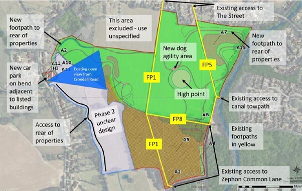
The proposal would directly affect many neighbouring properties and change the use of most of the fields at Cross Farm to a SANG. This would provide free open public access to the fields, a network of surfaced footpaths, landscaping and planting, a fenced dog agility area, construction of a new car park and access on the Crondall Road next to the River Hart and the junction with Stroud Lane. Some BNG is also proposed alongside the SANG. A large area to the North West between the long footpath across the field (FP1 on the diagram below) behind some houses and the garage is being retained for unspecified future use.
This diagram shows the extent of the SANG south of The Street and east of Crondall Road (green area) with wooded or part-wooded areas below that (hatched). Some of the hatched area is already common land and woods are not usually appropriate for SANG but they might be suitable for BNG. The square area at the top (grey) is excluded and its future use is unspecified. Existing footpaths (yellow) already traverse the land but are bounded by fences; the proposal for new paths around the field area is shown (green). The design of the floodplain (light grey area bounded in blue) is left to later although the car park (left, in red) is in this area and, as a SANG, paths have to start and end there.
As a ‘full’ planning application, this proposal requires an explicit ‘approve’ or ‘refuse’ decision from the Hart planning department. Unfortunately we believe that although the current proposal has merits there are some critical issues and concerns that may make it unacceptable as it stands.
These are the main potential benefits that we can see with this proposal:
- Designation as SANG could protect (most of) the land from housing and other development for 80 years and its use for BNG would similarly protect the land for at least 30 years.
- The proposal could preserve some open space in Crookham Village and maintain connectivity of the public rights of way.
- The proposal could support some biodiversity around the SANG and potentially improve and connect wildlife corridors.
- The proposal could remove the fencing of footpaths and provide access to new areas and views not currently accessible
We see the main issues and concerns with this proposal as follows:
- There has been no public consultation to allow expression of views, needs, assessment of options and modification.
- Construction of a car park on flooded land on a blind bend in Crondall Road is dangerous and an unsuitable location.
- The car park is in the Conservation Area. The change of character would damage the setting of both the conservation area itself and several listed buildings.
- The car park would mean the loss of one of the few remaining unbuilt roadside areas and sacrifice one of the village’s key views protected in the Neighbourhood Plan and specifically noted as a main feature of this part of the Conservation Area.
- Based on the current design, the paving, surfaced paths, infrastructure, metal fences, bins and signposts would 'urbanise' Cross Farm and its setting, changing the character of the village with loss of sense of place.
- The access for the car park requires removal of an important oak tree and the historic fencing both of which are noted as key features of the conservation area.
- Wildlife would be impacted by walkers, recreation and free-roaming dogs (a requirement of SANG).
- The unspecified future of the large retained ‘grey area’ to the north of the site and excluded from the SANG, potentially for development, could further damage amenity and views.
- The proposal would increase public access and use, reducing the value of the land as a quiet local gap between settlements.
- Proposed paths and accessible areas are right next to neighbouring properties, causing noise, intrusion, loss of privacy and security concerns especially for those in the Conservation Area or listed buildings, which are not permitted to erect fencing.
- The current design offers no new connectivity. The existing footpath network already provides routes through the site.
- The metal-fenced dog agility area is unnecessary (there is already one in Hitches Lane and one on Pilcot Farm) and in a very visually intrusive location. The municipal feel of this changed land-use would be inconsistent with the current rural setting.
- The wetlands and fields particularly along Crondall Road are frequently flooded. SANG requires a circular walk from the paved car park which would necessitate raised walkways, increasing the built, urbanised feel and change of character.
- The lack of detail of ‘Phase 2’, reserved grey area and unsuitability of much of the wet land leaves many unknowns.
- Governance, management, monitoring and maintenance, including financial provision for the long term, are unclear.
What Do You Think?
Unfortunately there has been no prior public consultation, which has caused concern. The application documents appear more like a request for pre-application advice or outline planning permission, but have been submitted as a full planning application and therefore Hart has to decide whether to accept or refuse the application as it stands.
The application was considered by the planning committee of Crookham Village Parish Council on 7th January. Many local residents attended to express their views. CVPC will formally object to the proposal as an official consultee.
Whilst we think many of the concerns raised above are major issues, we are still hopeful of a solution preserving our valuable local gap and open spaces and benefitting the environment, preferably with enhanced value through BNG rather than as SANG.

